Getting to the ancient quarries
QUICK DIRECTIONS
Take the back road from Kifissia to Nea Pendeli (going round the base of Pendeli mountain) and about half way along turn left up the mountain towards the quarries & monastery.
Go up the mountain for approx. 6 Km (do not turn left for the monastery) until near the top.
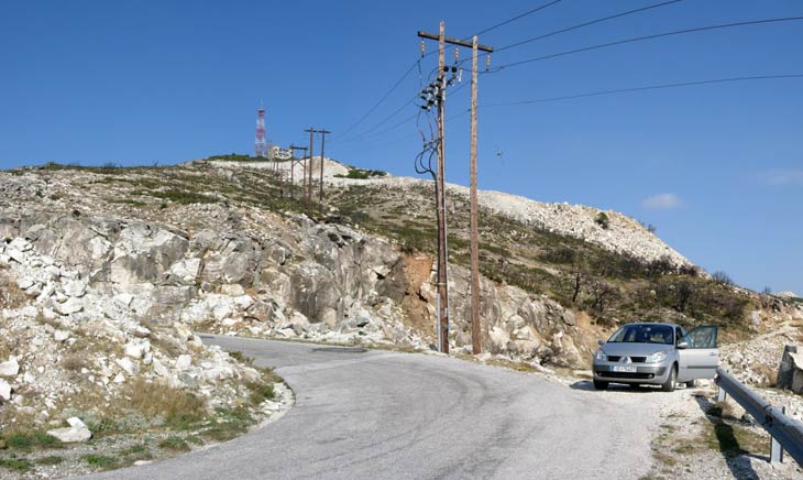
Park at a parking area on a sharp left-hand bend - next to wooden columns for electric power.
(Parking location: 38° 04' 38.50" N, 23° 52' 47.09" E )
DIRECTIONS (1)
From the centre of Athens -OR- from Kifissia area:
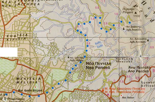
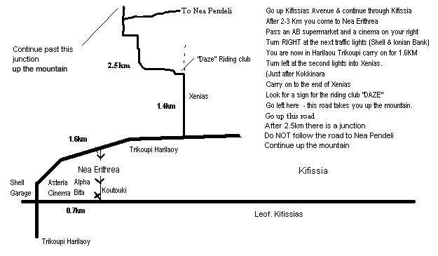
Go up Kifissias Avenue & continue through Kifissia
After 2-3 Km you come to Nea Erithrea
Pass an AB supermarket and a cinema on your right
At the next traffic lights (Shell garage & Bank) turn RIGHT
You are now in Harilaou Trikoupi carry on for 1.6Km
Turn left at the second lights into Xenias.**
(Just after Kokkinara St.)
Carry on to the end of Xenias.
Go left here - this road takes you up to the mountain.
After 2.5km or so there is a road junction.
Turn left and go up the mountain road for about 5 Km (do not turn left for the monastery) - until near the top.
Look for the parking area on a sharp left-hand bend - next to wooden columns for electric power .
If coming on the Attiki Odos:
Take the exit for Kifissia Avenue
Head North (towards Kifissia)
Follow directions as above
DIRECTIONS (2)
From the centre of Athens -OR- Melissia area:
Take Kifissias Avenue going north (in the direction of Kifissia).
Turn right onto Odos Pendelis for Melissia.
(Note the Maroussi platia & the Germanos building on the left-hand side as you turn).
Keep on this road (it takes a sharp left & right bend over a bridge) and then becomes Odos Demokratias.
Continue up through Melissia high street & come to a busy junction.
(note an Alpha Bank on the left and a Eurobank on the right).
Go straight ahead (a slight left & right turn required) for Nea Pendeli (Do not bear right for Vrilissia).
Reset your Odometer (Kilometres) to zero at this junction.
GO TO CONTINUE...
From the northern suburbs of Athens:
Get to Melissia high street going north & pass through the main shopping area.
Continue up through Melissia high street & come to a busy junction.
(Note an Alpha Bank on the left and a Eurobank on the right).
Go straight ahead (a slight left & right turn required) for Nea Pendeli (Do not bear right for Vrilissia).
Reset your Odometer (Kilometres) to zero at this junction.
GO TO CONTINUE...
CONTINUE:
0.0 Melissia junction
(Note - in about 100 metres you pass the Melissia Post Office on your right)
0.5 Take RIGHT lane at the division in the road - so continuing straight & keep straight on
2.2 Pendeli mountain looms ahead
2.6 Turn LEFT at junction with stop sign (and proceed up short steep hill section) & keep straight
3.0 Road narrows, then sharp left-hand bend.
3.4 Road levels out. View of pine trees on mountainside.
4.1 Pass under pylon cables.
4.2 Turn RIGHT up the mountain road signposted "Ag. Padelimona monastery - 3 Km"
(Note: You will now drive up the mountain for about 6 Km)
6.4 Road Junction, Shrine, & left-pointing sign for the monastery dead ahead. Bear RIGHT here and continue until you see the parking area on a sharp left-hand bend near the top of the mountain - next to wooden columns for electric power.
MAP showing route from Melissia:
MAP showing route from Kifissia:
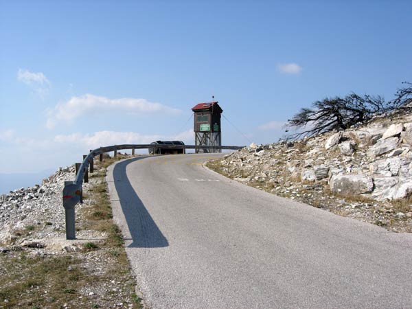
On the way up the mountain to the parking point:
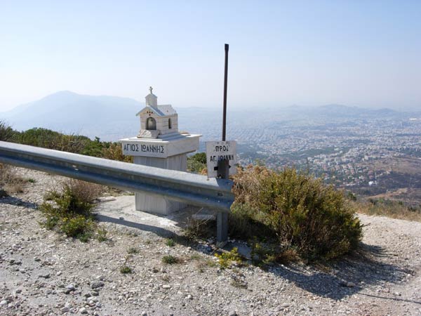
(The path down to the Agios Ioannis church)
The turn-off to the parking area:
Drive through the gap & down to the small parking area.
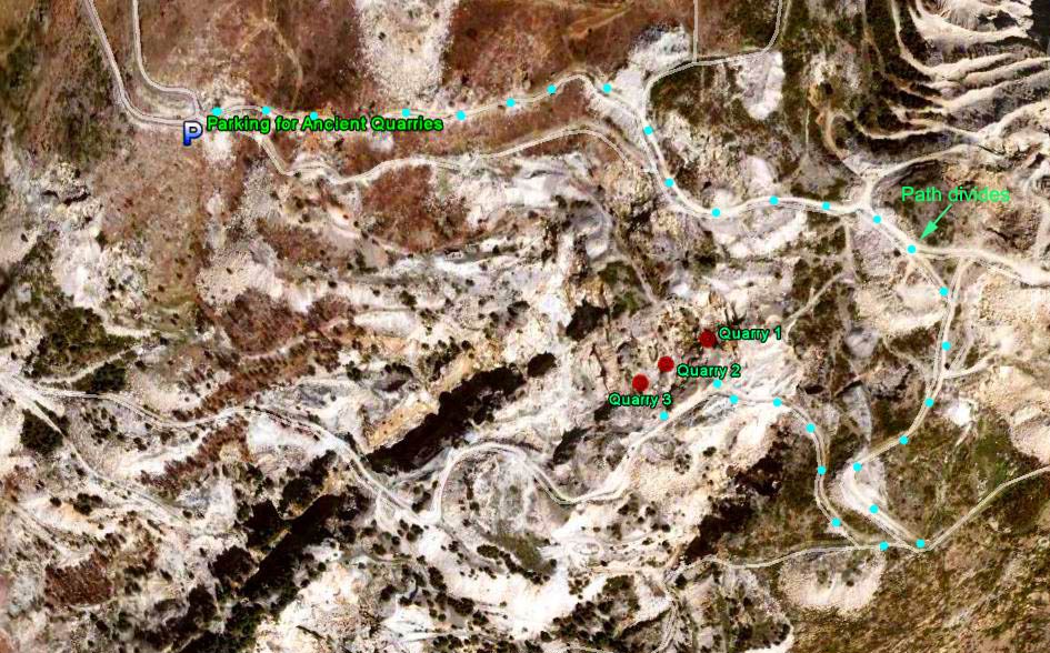
From where the car is located take the UPPER path and continue on this main path until you reach the
following divide:
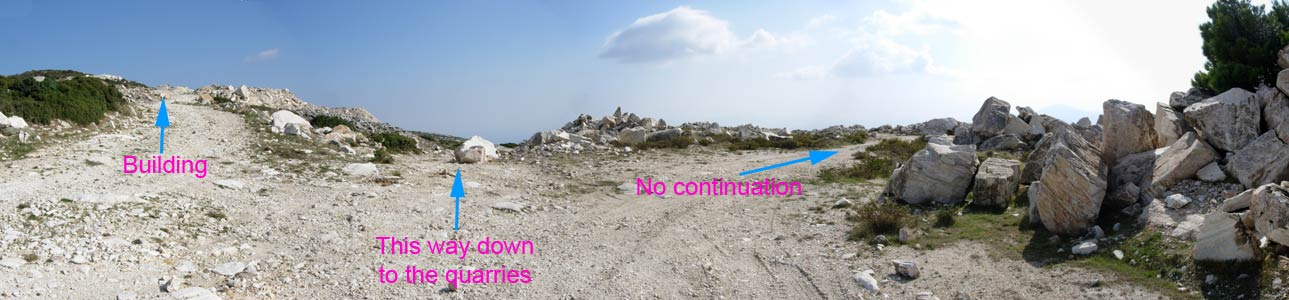
Take the central path, then later when connecting with a lower path turn right onto this new path & continue on down to the ancient quarries.
Suggestions:
Take a GPS navigator and enter the location of Quarry-1 as a waypoint to steer to when you reach the lower paths..
Quarry 1: 38° 04' 32.70" N, 23° 53' 07.00" E
Quarry 2: 38° 04' 31.94" N, 23° 53' 05.42" E
Quarry 3: 38° 04' 31.36" N, 23° 53' 04.44" E
Also suggest recording the location of the car park ( 38° 04' 38.50" N, 23° 52' 47.09" E) as a waypoint to steer back to if the weather turns bad or the clouds come down and create low visibility... which can easily happen at this high altitude. Straying from the paths can be extremely dangerous in these areas in fog or mist as there are many sheer drops into quarries.